![]() | ImageJ Plugins by i3mainz
| ImageJ Plugins
| ImageJ
| Privacy
| Imprint
| ImageJ Plugins by i3mainz
| ImageJ Plugins
| ImageJ
| Privacy
| Imprint


XYZ2DEM Importer - Tutorials, Examples, Applications
The ImageJ plugin XYZ2DEM Importer imports X,Y,Z coordinates of (usually irregularly distributed) points from the first 3 columns of a plain text file and interpolates a Digital Elevation Model (DEM) image using a Delaunay triangulation. Author: Martin Schlüter (ij ms3d.de), i3mainz
Contributor: Barry Joe, author of Geompack History: 2023/03/31: Public user success stories linked
2012/07/01: Optionally create a Tiff World File '.tfw'
2012/07/01: Rename result to file extension '.tif'
2009/04/23: Fix (removes java generics compiler warnings)
2005/02/22: First versionOpen Source: Download XYZ2DEM Importer from National Institutes of Health.
Download XYZ2DEM Importer from local mirror.
Short Tutorials: 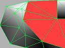
How to Set Appropriate Input Parameters: Let XYZ2DEM Importer comply with the requirements of your application by manually selecting appropriate input parameters. This page offers a very small data set and discusses the results of typical parameter settings. See how your parameter settings influence the resulting Digital Elevation Image. 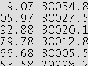
Notes on Input Text File Formats: XYZ2DEM Importer accepts several delimiters and notations of comments. An example shows common possibilities. 
Notes on Geocoding: XYZ2DEM Importer optionally keeps the geocoding of your raster image in a world file. Learn how to pass your ImageJ results to Geographic Information Systems!
Educational Tutorials Including Large Data Sets: 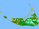
Import a Digital Elevation Model image of Nantucket Island. This example demonstrates the typical use of XYZ2DEM Importer using a real world data set. Using a proper chosen Maximum edge length parameter, we additionally obtain an approximate coastline. 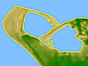
Import a Digital Elevation Model image of Nantucket Island and apply a coastline polygon. Here we explain how to proceed if an a priori known outline polygon of the input data is given. This example is intended for comparison with the results from the strategy above.
Background Reading: 
A scientific survey on Triangle-Based Surface Models by Leila De Floriani, Paola Magillo, Silvia Bussi and Elsag Bailey, Intelligent Systems and Robotics, 2000. Get a local copy of the pdf document here.
Public User Success Stories: 
The ImageJ plugin XYZ2DEM Importer seems to be increasingly cited in the context of Open Data. Please bring to our attention any other Open Access publications that use this tool:
K. McGrath, L.S. Limmer, A.L. Lockey et al.: 3D enamel profilometry reveals faster growth but similar stress severity in Neanderthal versus Homo sapiens teeth. Nature Scientific Reports 11, 522, https://doi.org/10.1038/s41598-020-80148-w, 2021.
P. Gueriau, S. Réguer, N. Leclercq, C. Cupello, P.M. Brito, C. Jauvion, S. Morel, S. Charbonnier, D. Thiaudière, C. Mocuta: Visualizing mineralization processes and fossil anatomy using synchronous synchrotron X-ray fluorescence and X-ray diffraction mapping. Journal of the Royal Society Interface.17: 20200216. Dryad, Dataset, https://doi.org/10.5061/dryad.s7h44j13z, 2020.
K. McGrath: From the Inside Out: Understanding Stress-Related Enamel Defects in Great Ape Canines. Electronic Thesis/Dissertation, 2018.
D. Tsvirkun, A. Grichine, A. Duperray, C. Misbah, L. Bureau: Microvasculature on a chip: study of the Endothelial Surface Layer and the flow structure of Red Blood Cells. Nature Scientific Reports 7, 45036, https://doi.org/10.1038/srep45036, 2017.
E. Paixão, J. Marreiros, J.Gibaja, T. Pereira, N. Bicho: 3D modeling to help the understand of Ground Stones wear-traces: Experimental program in Quartzite and Greywacke. Poster, Leibniz-Zentrum für Archäologie (LEIZA), Mainz, 2017.
A. Pope, I.C. Willis, W.G. Rees, N.S. Arnold, F. Pálsson: Combining airborne lidar and Landsat ETM+ data with photoclinometry to produce a digital elevation model for Langjökull, Iceland. International Journal of Remote Sensing, 34:4, 1005-1025, http://dx.doi.org/10.1080/01431161.2012.705446, 2012.
M. Schlüter, L. Pfeiffer, K. Berner, C. Weides: Deformation Analysis of Sandwich Surfaces Prior to Buckling Failure Employing a 3-d Scanning System and Open Source Image Processing Software. Photogrammetrie - Fernerkundung - Geoinformation (PFG) vol. 6, 2006.
M. Linscheid, M. Schlüter: Vom 3D-Objekt zur 3D-Kopie - Mobiles Aufmaß einer Bronzeplastik unter Einsatz eines handgeführten 3D-Scanners am 3D-Gelenkmessarm. F. Boochs und H. Müller (Hg.): Entwicklungen auf dem Gebiet der Informations- und Messtechnik, Festschrift zur Verabschiedung von Prof. Dr. Wolfgang Böhler, Schriftenreihe Informations und Messtechnik, Bd. 6, 59-66, Shaker Verlag, Aachen, 2005.
K. Berner, L. Pfeiffer, M. Schlüter, C. Weides: Mit 3D-Scanning zur Erfassung des Knitterversagens von Sandwichpaneelen. Ingenieurvermessung 2004, Zürich, 15.-19. März 2004.
![]() | ImageJ Plugins by i3mainz
| ImageJ Plugins
| ImageJ
| Privacy
| Imprint
| ImageJ Plugins by i3mainz
| ImageJ Plugins
| ImageJ
| Privacy
| Imprint
© 2014/04/29