![]() | XYZ2DEM Importer - Tutorials, Examples, Applications
| ImageJ Plugins by i3mainz
| ImageJ
| Privacy
| Imprint
| XYZ2DEM Importer - Tutorials, Examples, Applications
| ImageJ Plugins by i3mainz
| ImageJ
| Privacy
| Imprint
XYZ2DEM Importer - How to set Appropriate Input Parameters
Let XYZ2DEM Importer comply with the requirements of your application by manually selecting appropriate input parameters. This page offers a very small data set and discusses the results of typical parameter settings. See how your parameter settings influence the resulting Digital Elevation Image.
Preliminaries:
- Download and install XYZ2DEM Importer.
- Download input data: synthetic.txt.
Example 1: Import synthetic.txt: Plugins > XYZ2DEM Importer: synthetic.txt
by simply using the automatically proposed set of input parameters!Example 2: Import synthetic.txt: Plugins > XYZ2DEM Importer: synthetic.txt
using the following set of input parameters:
Length of one pixel: 0.04
Maximum edge length: 0.00
Background value: 0.00
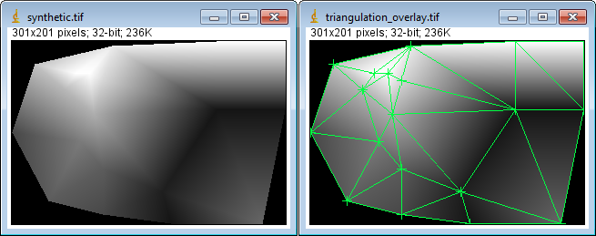
The left image shows the result of the operation. The right image shows additionally the Delaunay triangulation of the input data. For each image pixel position within the convex hull of the triangulation, a signed 32-bit floating-point pixel value Z=Z(X,Y) is calculated by linear interpolation within the corresponding triangle. Pixel positions outside the convex hull get the user chosen background value of 0.0. Since the background value is below the minimum of the given Z-values, the background appears black.
XYZ2DEM Importer refers a pixel value always to the X/Y-coordinate of the according image pixel center. This allows an easy representation of plot profiles e.g. with precise scale. For the given example we find a difference between the maximum and minimum X-value of 22.0mm - 10.0mm = 12.0mm. This results in a distance of 12.0mm / 0.04mm = 300.0 pixels from the center of the upper left image pixel to the center of the upper right image pixel. The width of the complete image results to 301 pixels. Please use the protocol checkbox to learn more about the transformation of your coordinates.
Example 3: In many cases the convex hull of your data is not what you expect to be the outline your data. If your X,Y,Z coordinates are more or less regularly spaced, a quick and easy way to achieve a better result is to disregard triangles depending on their maximum edge length:
Import synthetic.txt:
Plugins > XYZ2DEM Importer: synthetic.txt
using the following set of input parameters:
Length of one pixel: 0.04
Maximum edge length: 5.00
Background value: 1.80
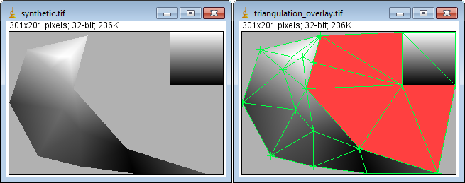
The left image again shows the result of the operation. The background area has grown, because all triangles with an edge length greater than 50.0 have been omitted. These triangles are marked red within the right image.
Disregarding triangles depending on their maximum edge length is a quick and easy way to deal with data containing irregular outlines or even holes. Nevertheless, the accuracy of the resulting outline is limited by the point density of sparse areas. Please use this option carefully - undersizing the maximum edge length will cause too many holes or even a pure background image! The precise way to deal with region boundaries is to use an a priori known Region Of Interest (ROI) - if at hand.
Due to the new background value of Z = 1.8 the background now appears lighter.
![]() | XYZ2DEM Importer - Tutorials, Examples, Applications
| ImageJ Plugins by i3mainz
| ImageJ
| Privacy
| Imprint
| XYZ2DEM Importer - Tutorials, Examples, Applications
| ImageJ Plugins by i3mainz
| ImageJ
| Privacy
| Imprint
© 2006/01/16