![]() | XYZ2DEM Importer - Tutorials, Examples, Applications
| ImageJ Plugins by i3mainz
| ImageJ
| Privacy
| Imprint
| XYZ2DEM Importer - Tutorials, Examples, Applications
| ImageJ Plugins by i3mainz
| ImageJ
| Privacy
| Imprint
XYZ2DEM Importer - Notes on Input Text File Formats
XYZ2DEM Importer accepts several delimiters and notations of comments. An example shows common possibilities.
Preliminaries:
- Download and install XYZ2DEM Importer.
- Download input data: five_points_without_comments.txt and five_points_with_comments.txt.
Examples: This ImageJ plugin imports X,Y,Z coordinates of (usually irregularly distributed) points from the first 3 columns of a plain text file. Usually the text file looks someway like the example five_points_without_comments.txt:
9.600 29.600 4000.000
17.600 2.96e+01 2100.000
17.600 0037.600 1600.000
9.600 37.600 8600.000
13.300 33.300 9999.999
The text parser also accepts different separation characters like colons or commas. Several single-line comments are supported; find out more by studying the example five_points_with_comments.txt below, which leads to the same DEM image as the example above:
// This is a single line comment
# This is a single line comment
# Empty lines will be ignored!
# The following line will be accepted:
9.600 /* this is a comment */ 29.600 4000.000
# Scientific notation will be accepted:
17.600 2.96e+01 2100.000
# More than three numbers in one line will be ignored:
17.600 0037.600 1600.000 22.2 3.5
# The following line will be accepted:
9.6;37.6 , 8600.000
# The following line will be ignored because
# the third coordinate is missing:
12.600 47.600
# ONE of the following lines will be ignored
# because X and Y of both points are equal;
# please check the displayed numbers of
# accepted and eliminated points:
13.300 33.300 9111.111
13.300 33.300 9999.999
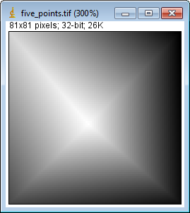
It is not recommended to use Java-style multi-line comments, though simple Java-style multi-line comments are supported; nesting single line comments within multi-line comments might yield to unexpected results, please be careful.Import: Import five_points_without_comments.txt:
Plugins > XYZ2DEM Importer: five_points_without_comments.txt
using the following set of input parameters:
Length of one pixel: 0.1
Maximum edge length: 0.0
Background value: 1600.0
This leads to the resulting DEM image:
Import five_points_with_comments.txt:
Plugins > XYZ2DEM Importer: five_points_with_comments.txt
using the same set of input parameters as above.
Now the parameter window indicates that one points was eliminated:
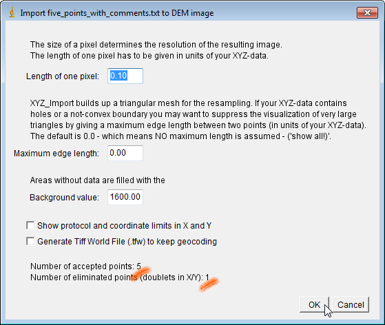
The resulting DEM image should be the same as the one above.
![]() | XYZ2DEM Importer - Tutorials, Examples, Applications
| ImageJ Plugins by i3mainz
| ImageJ
| Privacy
| Imprint
| XYZ2DEM Importer - Tutorials, Examples, Applications
| ImageJ Plugins by i3mainz
| ImageJ
| Privacy
| Imprint
© 2012/07/02