Open Geospatial FundamentalsImageJ Plugins - Digital Image Processing |
|
|
These plugins extend the
open source image processing software
ImageJ
with respect to fundamental applications in geoinformatics and surveying.
While ImageJ isn't Photoshop - and is not meant to be -, it's quite a capable program,
and thanks to a macro recording facility and a powerful Java API, it's much easier to extend.
Being in the public domain, it's also free, and bugs are generally fixed quickly.
The plugins below should integrate well under other distributions of ImageJ, like
Fiji, too.
Download and install the latest version of ImageJ bundled with Java first (if not yet done). |
|
|
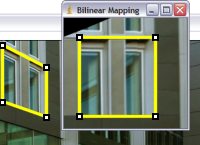
Geometric Mappings. Understand basic image rectification techniques using control points. Learn to distinguish the proper use of affine, perspective and bilinear mapppings. |
|
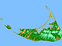
Delaunay Triangulation and Interpolation. XYZ2DEM_Importer meshes and interpolates irregular distributed XYZ-coordinates. Find out more by exploring some exemplary data sets. |
|
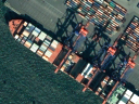
Color transforms for image fusion. Explore how to merge satellite image data using IHS color transforms. |
|
These plugins are actually provided by
Martin Schlüter,
Hochschule Mainz University of Applied Sciences.
If you would like to contribute to any of these efforts contact
ij |
|